
JULIA is a project that aims to leverage the EU Space services in the public transport market, build awareness about Galileo and Copernicus products and analyse current needs of public transport operators. It will do so by advancing existing, mature public transport-oriented, user-centric applications leveraging digital technologies, and piloting them to mature, market-ready solutions.
- Title: JULIA - Joint developments for Urban resilience connecting users to public transport through space technology
- Funder: EUSPA
- Duration: 30 months
Keywords: EGNSS, GNSS, Galileo, Copernicus, OSNMA, HAS, Public Transport, Demand Responsive Transport
Scope
The scope of JULIA covers the application of both E-GNSS navigation technologies and European Earth Observation (EO) services in Public Transport use cases, with the goal to assess the impact of introducing those cutting-edge navigation and EO technologies in Public Transport operations. JULIA will provide the air quality assessments of various European cities using Copernicus data as well as the navigation performances with EGNSS measurements and the validation of new ENGSS services: OSNMA and HAS. The technologies will be demonstrated in real cases scenarios on board of the public transport and DRT vehicles, like trains, buses and bikes.
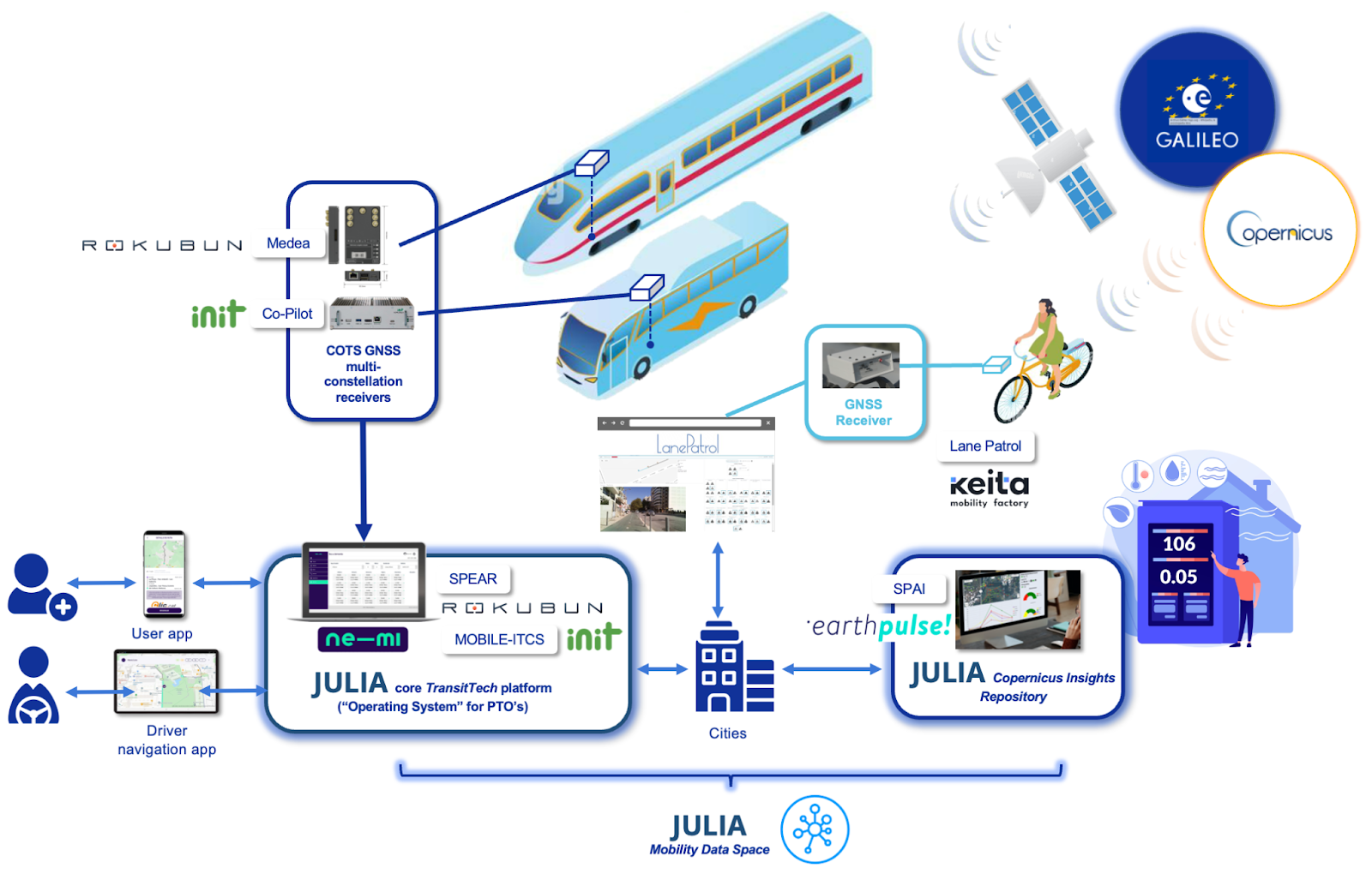
JULIA high-level architecture
The JULIA consortium of 13 partners led by FACTUAL started the collaboration on the 1st January 2024 and it will last for the next 30 months. Project is being mentored under the wings of EUSPA Horizon Europe programme.
Main objectives
Objective 1: Demonstrate EGNSS differentiators as enhancers of the long lead time, global Public Transport downstream market
Through a series of applications piloted in selected European cities leveraging Galileo’s Open Service (OS), High Accuracy Service (HAS) and Open Service Navigation Message Authentication (OSNMA), aiming at market readiness.
Objective 2: Leverage COPERNICUS data for climate action and urban mobility innovation
By demonstrating, through applications piloted in several European cities, the multiple ways in which Copernicus Atmosphere Monitoring Service (CAMS), Copernicus Climate Change Service (C3S), Copernicus Land Cover, and Copernicus Land Monitoring Service can provide valuable information to support sustainable mobility planning and end user awareness, contributing to make public transport more efficient and resilient to better respond to the impacts of climate change.
Objective 3: Support decision-making and foster thought leadership aimed at EGNSS & COPERNICUS investment and uptake in Public Transport:
By gathering requirements and piloting the vision of PTO’s in the project, adapting to each city local requirements with the goal of not only fulfilling their expectations but to identify scalability levers towards exploiting the JULIA Applications in many more metropolitan areas, unlocking bigger impact. Moreover, the “Global Observatory of EU Space Data & Services in Public Transport” developed under the framework of JULIA and co-led by POLIS and ERTICO will serve as a powerful tool to quantify the global impact of Galileo and Copernicus in public transport and amplify the message demonstrating its added value, reaching out to policy and decision makers worldwide.
Rokubun in JULIA
Navigation authentication is a critical feature for Public Transport Operators (PTO) in scenarios where the distance driven by the public transport vehicles is used to compute the cost, or fare price of the mobility service. Therefore, one of JULIA’s goals is to scale the use and importance of Galileo OSNMA capable receivers for public transport applications.
Rokubun, as partner specialised in positioning engineering domain, is engaged in the development of Galileo OSNMA (Open Service Navigation Message Authentication) and HAS (High Accuracy Service) modules ready to be integrated within different positioning platforms and used for various applications throughout the project.
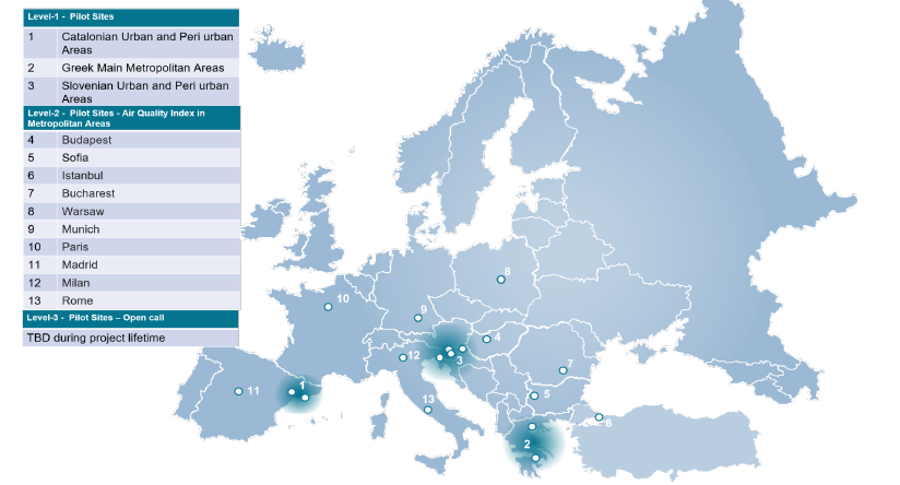
Moreover, Rokubun’s MEDEA GNSS computer with SPEAR positioning engine will be deployed in public transport vehicles as one of the positioning providers during the demonstration phase of the project. All real-time pilots and demonstrations will be supervised by Rokubun. Overall 12 months of testing phase will take place in the areas presented in the map and Level 1 pilots with GNSS equipment on public transport vehicles will be held in 3 countries: Spain, Greece and Slovenia.
Galileo’s innovations implemented by Rokubun will be applied in the following JULIA’s applications:
Accurate vehicle tracking with Galileo: buses, trams and trains transmit their position in near real-time, which allows the PTO to track them. The GNSS position can be used to display its live geographical position through a user app and provide a better ETA. With the real-time positioning of vehicles, the fleet operator can detect incidents such as important delays, detours, and breakdowns as soon as they happen and inform users. In contrast to traditional signalling systems that require physical infrastructure, GNSS can provide position information to trains in real-time, allowing for efficient and safe train control and will contribute to operational safety such as bridge warnings and speed warnings for the driver and at the control centre. In addition, Copernicus land cover maps could be used as a complementary information source to tune some configuration parameters of the positioning engine aiming at optimising navigation results.
Effective DRT pick-up process enhanced by Galileo: in DRT services, pick-up locations are typically not physically signalled, they are either virtual stops previously set up by the service provider, or a location provided by the user. A more accurate, reliable GNSS position of both the user’s personal mobile device (e.g., smartphone) and vehicle will optimise pick-ups, especially in two-way streets.