
Seamless outdoors-indoors localization is an open research topic yet to be solved with technology that can offer accurate, ubiquitous, and scalable navigation for industrial and mass-market applications. New mainstream technological trends such as Location-based Services (LBS), automotive, robotics, and IoT demand a location technology that can provide accuracy and ubiquity at an affordable cost that allows scalability to millions of users.
New positioning applications concentrate their demand in urban and very populated areas. While the Global Navigation Satellite System, GNSS, is a widely consolidated technology for outdoor navigation, it cannot provide a good performance location in harsh urban scenarios, indoor or mild-indoor environments. Therefore, complementary technology needs to aid GNSS in those scenarios to get a seamless and robust navigation solution.
The BANSHEE project aims at developing such a navigation technology for urban environments using tightly hybridizing GNSS with other ranging signals of opportunity such as Wi-Fi Fine Time Measurements (FTM), UWB, or 5G. The consortium is developing a fully operational demonstrator for the Wi-Fi FTM case, since Wi-Fi Access Points (WAPs) constitute a globally spread infrastructure with a massive presence in urban areas.
The basis of the BANSHEE technology is to use FTM-compliant WAPs (i.e., routers) to provide ranging measurements to locate the user's device. Therefore, the device needs accurate location knowledge of the WAP measurements to estimate its position.
The more accurate the position of the WAP is, the more precise the user's location will be.
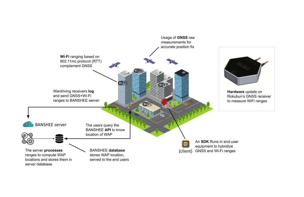
Traditionally, WAPs positions are manually computed based on their situation in a geo-referenced map or surveyed with ad-hoc campaigns. Tradicional alternatives are cumbersome and expensive, and in the former case, the results might not be very accurate.
One of our biggest challenges in this project is to localize the available FTM-compliant WAPs so cost-effectively and accurately that we can use them for navigation purposes. BANSHEE service end proposes a unique methodology to address this problem, which is currently a submitted European patent under evaluation. This methodology is based on inversely geolocating WAPs using ranging measurements gathered by a device embedding a GNSS receiver:
- Data collecting devices (e.g. Android smartphones) pack and send to BANSHEE service data batches of synchronized Wi-Fi FTM and GNSS measurements.
- Periodically, the BANSHEE service checks available data batches for a given WAP, coming from different positions and computes the location of the WAP that feeds a global WAP accurate locations database.
- This database is maintained and afterward served to navigation users by the BANSHEE service.
- Therefore, that devices can estimate their location using WAPs FTM measurements.
- Given that WAP FTM measurements are affected by a hardware bias, the BANSHEE service estimates this bias along with the WAP position and stores it in the database. The information is afterward provided to the navigation users to reach better accuracy.
With this automatic methodology, BANSHEE proposes a scalable and cost-effective technology for accurate and ubiquitous navigation in urban zones where the Wi-Fi Access Points infrastructure is widely deployed.
This technology could be easily upgraded to other ranging technologies such as UWB or 5G to add redundancy and ubiquity to the navigation solution.